Authors:Levy et alAbstract:We present an analysis of two concentrically-fractured depressions on Mars, one in northern Hellas and the second in Galaxias Fossae. Volumetric measurements indicate that ∼2.4 km3 and ∼0.2 km3 of material was removed in order to form the North Hellas and Galaxias depressions. The removed material is inferred to be predominantly water ice. Calorimetric estimates suggest that up to ∼103–105 m3 of magma would have been required to melt/sublimate such a volume of ice under an ice/magma interaction scenario. This process would lead to subsidence and cracking of the surface, which could produce the observed concentric fracture (crevasse-like) morphology. While the Galaxias Fossae landform morphology is consistent with an impact origin, the large volume of removed material in North Hellas is less consistent with an impact origin and is interpreted to have resulted from volcanic melting of ice. The possibility of liquid water formation during or subsequent to volcanism or an impact could generate locally-enhanced habitable conditions, making these features tantalizing geological and astrobiological exploration targets.
Showing posts with label hellas basin. Show all posts
Showing posts with label hellas basin. Show all posts
Friday, February 03, 2017
Candidate volcanic and impact-induced ice depressions on Mars
Friday, December 09, 2016
The Hellas Basin on Mars has the Remnants of an Ocean Frozen Within
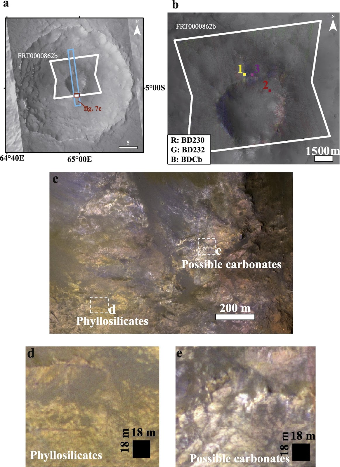
Authors:Weiss et alAbstract:The “honeycomb” terrain is a Noachian-aged cluster of ∼7 km wide linear cell-like depressions located on the northwestern floor of Hellas basin, Mars. A variety of origins have been proposed for the honeycomb terrain, including deformation rings of subglacial sediment, frozen convection cells from a Hellas impact melt sheet, a swarm of igneous batholiths, salt diapirism, and ice diapirism. Recent work has shown that the salt or ice diapirism scenarios appear to be most consistent with the morphology and morphometry of the honeycomb terrain. The salt and ice diapirism scenarios have different implications for the ancient martian climate and hydrological cycle, and so distinguishing between the two scenarios is critical. In this study, we specifically test whether the honeycomb terrain is consistent with a salt or ice diapir origin. We use thermal modeling to assess the stability limits on the thickness of an ice or salt diapir-forming layer at depth within the Hellas basin. We also apply analytical models for diapir formation to evaluate the predicted diapir wavelengths in order to compare with observations. Ice diapirism is generally predicted to reproduce the observed honeycomb wavelengths for ∼100 m to ∼1 km thick ice deposits. Gypsum and kieserite diapirism is generally predicted to reproduce the observed honeycomb wavelengths for ≥ 600–1000 m thick salt deposits, but only with a basaltic overburden. Halite diapirism generally requires approx. ≥ 1 km thick halite deposits in order to reproduce the observed honeycomb wavelengths. Hellas basin is a distinctive environment for diapirism on Mars due to its thin crust (which reduces surface heat flux), low elevation (which allows Hellas to act as a water/ice/sediment sink and increases the surface temperature), and location within the southern highlands (which may provide proximity to inflowing saline water or glacial ice). The plausibility of an ice diapir mechanism generally requires temperatures ≤ 250 K within Hellas in order to reproduce the observed diapir wavelength. Conversely, the viability of the salt diapir mechanism requires sufficiently thick evaporite deposits to accumulate in Hellas (generally ≃1–3 km), which requires the emplacement and evaporation within Hellas of a 14–2045 m global equivalent layer (GEL) of saline water (∼2 × 10⁶ km3 to ∼3 × 10⁸ km3). On the basis of our analysis, we conclude that ice diapirism is more likely due to the thin deposits (∼0.1–1 km thick) and low water volumes required (only 0.3–24 m GEL water), and the potential for either glacial deposits or a frozen ocean to supply the necessary ice. Salt diapirism requires thick evaporite deposits and high water volumes by comparison, and thus appears less likely.
Saturday, April 30, 2016
Evidence of Water Discharges From Nili Fossae and Syrtis Major on Mars
Extensive aqueous deposits at the base of the dichotomy boundary in Nilosyrtis Mensae, Mars
Authors:
Bandfield et al
Abstract:
Thermal emission imaging system (THEMIS) and Compact Reconnaissance Imaging Spectrometer for Mars (CRISM) spectral datasets were used to identify high bulk SiO2 and hydrated compositions throughout the Nilosyrtis Mensae region. Four isolated locations were identified across the region showing short wavelength silicate absorptions within the 8–12 μm spectral region, indicating surfaces dominated by high Si phases. Much more extensive exposures of hydrated compositions are present throughout the region, indicated by a spectral absorption near 1.9 μm in CRISM data. Although limited in spatial coverage, detailed spectral observations indicate that the hydrated materials contain Fe/Mg-smectites and hydrated silica along with minor exposures of Mg-carbonates and an unidentified hydrated phase. The high SiO2 and hydrated materials are present in layered sediments near the base of topographic scarps at the hemispheric dichotomy boundary, typically near or within low albedo sand deposits. The source of the high SiO2 and hydrated materials appears to be from groundwater discharge from Nili Fossae and Syrtis Major to the south, where there is evidence for extensive aqueous alteration of the subsurface. Although discontinuous, the exposures of high SiO2 and hydrated materials span a wide area and are present in a similar geomorphological context to previously identified deposits in western Hellas Basin. These regional deposits may reflect aqueous conditions and alteration within the adjacent crust of the martian highlands.
Friday, November 13, 2015
Mapping the Geology of the Hellas Basin on Mars
Photogeologic mapping and the geologic history of the Hellas basin floor, Mars
Authors:
Bernhardt et al
Abstract:
The Hellas basin on Mars is the second-largest topographically well-defined impact structure in the Solar System and has repeatedly been interpreted as a major sink of volcanic, glacio-fluvial and eolian materials. Based on established guidelines for planetary mapping, we compiled a comprehensive photogeological map of Hellas Planitia, i.e., the Hellas basin floor (1:2,000,000; ∼1.8 × 10⁶ km2; see Supplementary online material), using the Thermal Emission Imaging System (THEMIS-IR) day-time mosaic as basemap (supplemented by several other datasets). We identified 33 units, which were categorized into a “Rim Assemblage”, containing “Dissected units”, a “Layered rim sequence”, and “Other basin rim units”, as well as a “Floor Assemblage”, containing the “Honeycomb formation”, an “Interior formation”, and a “Plains sequence”. Relative dating of units was performed wherever contacts revealed stratigraphic relationships and was complemented by absolute model ages (AMAs) of all units that lend themselves to reliable crater-size frequency distribution (CSFDs) measurements. On the basis of our results, as well as AMAs of circum-Hellas volcanic provinces by previous authors, we compiled a chronostratigraphic model of the Hellas basin floor. The northern basin rim shows evidence (vast layered, hydrous mineral-bearing deposits containing meandering, channel-like valleys), that the early history of the basin until ∼3.8 Ga ago experienced extended periods of low-energy fluvial, and possibly lacustrine, activity. Superposing the layered rim sequence, the majority of the Hellas basin infill (∼1.5–1.7 × 10⁶ km3) consists of volcanic material (a lower and an upper wrinkle-ridged plains unit), which was shortened by a compressive stress field relatively soon after its emplacement. Based on their ages and stratigraphic considerations, we identified Malea Patera (and possibly also Tyrrhena Patera) as a suitable source for the older, lower plains (∼3.8 Ga), and Hadriaca and/or Amphitrites Paterae for the younger, upper plains (∼3.7 Ga). Shortly after these volcanic episodes, the entire basin floor was covered by large amounts of deposits (greater than 106 km3) containing aqueously altered mafic materials. We interpret the deposits to have originated from Hesperia Planum and the Hesperia-Hellas trough, where they might have been removed by glacio-fluvial processes, which also sculpted the Hellas rim sections along northern Promethei Terra and Malea Planum around the same time. Such an apparent correlation between nearby volcanic activity and increased erosion/deposition is in agreement with previous models, which suggest outgassing by a maximum in global volcanism at that time caused warmer episodes enabling repeated subaerial water run-off. After the emplacement of these deposits, intense erosion, likely deflation along a rim-parallel annulus, began to exhume the outer parts of the wrinkle-ridged plains again, forming an interior formation of more elevated erosional remnants including the Alpheus Colles. Since ∼3.7 Ga ago, fluvial activity of Dao/Niger and Harmakhis Valles dissected the eastern plains and emplaced pancake-shaped deposits in the basin center. Later, deflation and abrasion by katabatic winds moving through the Hellas basin in a clock-wise direction parallel to the basin floor outline carved out the northwestern Hellas Planitia trough (called Peneus Palus), possibly within a time span of few hundreds of Ma or less within the Amazonian. Being consistent with erosional patterns we observed within the basin, circulation models predict such winds to be ongoing today and might, thus, have recently exhumed the so called “honeycomb” formation on parts of Peneus Palus. This enigmatic, unique terrain was possibly formed by ductile deformation of pre-3.8 Ga material and appears to be partially covered by another unique landform, the “banded terrain”. Although we cannot rule out that it is the surface expression of a thicker unit, the banded terrain might represent flows of volatile-rich airfall deposits emplaced along the edges of the Hellas wind alley by turbulent, marginal wind currents, which currently/recently prevail on both sides of the Hellas Planitia trough. In summary, our investigations enabled us to draw an updated, comprehensive and self-consistent picture of the geologic evolution of the Hellas basin floor, including volcanic, (peri-)glacial, fluvial and eolian processes, their possible interactions, and the implications on the climatic and geologic development of the circum-Hellas region and the entire planet.
Wednesday, July 29, 2015
Evidence of Carbonation of the Deep Martian Crust in the Isidis and Hellas Basins
Deep alteration between Hellas and Isidis Basins
Authors:
Bultel et al
Abstract:
Recent investigations of alteration of martian crustal outcrops suggest putative crustal hydrothermal systems, which are favorable environments for the emergence of life. In this study, we perform an analysis of the CRISM targeted observations covering crustal outcrops in the region between the Hellas and Isidis basins with the goal of investigating the alteration phases. Over the wide studied region, we detect the presence of possible serpentines, chlorites, smectites and carbonates. These detections occur within ejecta blankets, crater walls and central uplifts of impact craters. We investigate the relation between the observed associations of minerals and the ages of the impact craters assessed by crater count. No clear relation is observed. We also investigate the relationship between the group of detected mineral and the pre-impact depth of the studied outcrops assessed from the size of the impact craters. This method allows us to reconstruct the pre-impact cross-section. We suggest that alteration of the first 7 km of the crust between the Hellas and Isidis basins may have undergone alteration processes.
Wednesday, July 23, 2014
What *IS* the Banded Terrain in the Martian Hellas Basin
The geomorphology and morphometry of the banded terrain in Hellas basin, Mars
Authors:
Diot et al
Abstract:
Hellas basin is a large impact basin situated in the southern highlands of Mars. The north-western part of the basin has the lowest elevation (−7.5 km) on the planet and contains a possibly unique terrain type, which we informally call “banded terrain”. The banded terrain is made up of smooth-looking banded deposits that display signs of viscous behavior and a paucity of superimposed impact craters. In this study, we use newly acquired high spatial resolution images from the High Resolution Imaging Science Experiment (HiRISE) in addition to existing datasets to characterize the geomorphology, the morphometry and the architecture of the banded terrain. The banded terrain is generally confined to the NW edge of the Alpheus Colles plateau. The individual bands are ∼3–15 km-long, ∼0.3 km-wide and are separated by narrow inter-band depressions, which are ∼65 m-wide and ∼10 m-deep. The bands display several morphologies that vary from linear to concentric forms. Morphometric analysis reveals that the slopes along a given linear or lobate band ranges from 0.5° to 15° (average ∼6°), whereas the concentric bands are located on flatter terrain (average slope ∼2–3°). Crater-size frequency analysis yields an Amazonian-Hesperian boundary crater retention age for the terrain (∼3 Gyr), which together, with the presence of very few degraded craters, either implies a recent emplacement, resurfacing, or intense erosion. The apparent sensitivity to local topography and preference for concentrating in localized depressions is compatible with deformation as a viscous fluid. In addition, the bands display clear signs of degradation and slumping at their margins along with a suite of other features that include fractured mounds, polygonal cracks at variable size-scales, and knobby/hummocky textures. Together, these features suggest an ice-rich composition for at least the upper layers of the terrain, which is currently being heavily modified through loss of ice and intense weathering, possibly by wind.
Subscribe to:
Comments (Atom)