Showing posts with label water. Show all posts

Friday, November 18, 2016

Meteorites Show Mars Dry, Inhospitable for Billions of Years

he lack of liquid water on the surface of Mars today has been demonstrated by new evidence in the form of meteorites on the Red Planet examined by an international team of planetary scientists.

In a study led by the University of Stirling, an international team of researchers has found the lack of rust on the meteorites indicates that Mars is incredibly dry, and has been that way for millions of years.

The discovery, published in Nature Communications, provides vital insight into the planet's current environment and shows how difficult it would be for life to exist on Mars today.

Mars is a primary target in the search for life outside Earth, and liquid water is the most important pre-requisite for life.

Dr Christian Schröder, Lecturer in Environmental Science and Planetary Exploration at the University of Stirling and Science Team Collaborator for the Mars Exploration Rover Opportunity mission, said:

"Evidence shows that more than 3 billion years ago Mars was wet and habitable. However, this latest research reaffirms just how dry the environment is today. For life to exist in the areas we investigated, it would need to find pockets far beneath the surface, located away from the dryness and radiation present on the ground."

A study published last year, which used data from the Curiosity Rover investigating Gale crater on Mars, suggested that very salty liquid water might be able to condense in the top layers of Martian soil overnight.

"But, as our data show, this moisture is much less than the moisture present even in the driest places on Earth," explains Dr Schröder.

Tuesday, June 21, 2016

The Shorelines & Drainage Systems of Mars


Waterfront on the Martian Planitia: Algorithmic emergent catchments on disordered terrain

Authors:

Handmer et al

Abstract:

Under a terraforming scenario, a reactivated hydrological cycle on Mars will result in upwards movement of water due to evaporation and precipitation. If Mars' embryonic fossilized catchments provide inadequate drainage, Mars' limited supplies of water may be absorbed entirely by crater lakes and glaciers, with negative consequences for the terraforming effort. We demonstrate a stable, convergent algorithm for the efficient modeling of water flow over disordered terrain. This model is applied to Mars Orbital Laser Altimeter data and successfully predicts the formation of fossilized waterways and canyons visible only at much higher resolution. This exploratory study suggests that despite its impossibly rugged appearance, ancient water flows have carved channels that provide effective drainage over the majority of Mars' surface. We also provide one possible reconstruction of a terraformed surface water distribution.

Tuesday, May 17, 2016

There Were Multiple Watery Episodes in the Nili Fossae on Mars


Elevated bulk-silica exposures and evidence for multiple aqueous alteration episodes in Nili Fossae, Mars

Authors:

Amador et al

Abstract:

The Nili Fossae region of Mars contains some of the most mineralogically diverse bedrock on the planet. Previous studies have established three main stratigraphic units in the region: a phyllosilicate-bearing basement rock, a variably altered olivine-rich basalt, and a capping rock. Here, we present evidence for the localized alteration of the northeast Nili Fossae capping unit, previously considered to be unaltered. Both near-infrared and thermal-infrared spectral datasets were analyzed, including the application of a method for determining the relative abundance of bulk-silica (SiO2) over surfaces using thermal emission imaging system (THEMIS) images. Elevated bulk-silica exposures are present on surfaces previously defined as unaltered capping rock. Given the lack of spectral evidence for phyllosilicate, hydrated silica, or quartz phases coincident with the newly detected exposures—the elevated bulk-silica may have formed under a number of aqueous scenarios, including as a product of the carbonation of the underlying olivine-rich basalt under moderate water: rock scenarios and temperatures. Regardless of formation mechanism, the detection of elevated bulk-silica exposures in the Nili Fossae capping unit extends the history of aqueous activity in the region to include all three of the main stratigraphic units.

Saturday, April 30, 2016

Evidence of Water Discharges From Nili Fossae and Syrtis Major on Mars

Extensive aqueous deposits at the base of the dichotomy boundary in Nilosyrtis Mensae, Mars

Authors:

Bandfield et al

Abstract:

Thermal emission imaging system (THEMIS) and Compact Reconnaissance Imaging Spectrometer for Mars (CRISM) spectral datasets were used to identify high bulk SiO2 and hydrated compositions throughout the Nilosyrtis Mensae region. Four isolated locations were identified across the region showing short wavelength silicate absorptions within the 8–12 μm spectral region, indicating surfaces dominated by high Si phases. Much more extensive exposures of hydrated compositions are present throughout the region, indicated by a spectral absorption near 1.9 μm in CRISM data. Although limited in spatial coverage, detailed spectral observations indicate that the hydrated materials contain Fe/Mg-smectites and hydrated silica along with minor exposures of Mg-carbonates and an unidentified hydrated phase. The high SiO2 and hydrated materials are present in layered sediments near the base of topographic scarps at the hemispheric dichotomy boundary, typically near or within low albedo sand deposits. The source of the high SiO2 and hydrated materials appears to be from groundwater discharge from Nili Fossae and Syrtis Major to the south, where there is evidence for extensive aqueous alteration of the subsurface. Although discontinuous, the exposures of high SiO2 and hydrated materials span a wide area and are present in a similar geomorphological context to previously identified deposits in western Hellas Basin. These regional deposits may reflect aqueous conditions and alteration within the adjacent crust of the martian highlands.

Monday, April 11, 2016

How did the Maya Manage Their Water Resources?

Collection, storage and management of water were top priorities for the ancient Maya, whose sites in Mexico, Belize and Guatemala were forced to endure seven months out of the year with very little rainfall. As researchers expand their explorations of the civilization outside of large, elite-focused research site centers, aerial imagery technology is helping them locate and study areas that are showing them how less urbanized populations conserved water for drinking and irrigation. The NSF-supported research by Jeffrey Brewer, a doctoral student in the University of Cincinnati's Department of Geography, and Christopher Carr, a UC research assistant professor of geography, was presented at the 81st annual meeting of the Society of American Archaeology. The meeting takes place April 6-10, in Orlando, Florida.

Saturday, April 02, 2016

There was a Water Reservoir Deep Within the Earth During the Archean

Komatiites reveal a hydrous Archaean deep-mantle reservoir

Authors:

Sobolev et al

Abstract:

Archaean komatiites (ultramafic lavas) result from melting under extreme conditions of the Earth’s mantle. Their chemical compositions evoke very high eruption temperatures, up to 1,600 degrees Celsius, which suggests even higher temperatures in their mantle source. This message is clouded, however, by uncertainty about the water content in komatiite magmas. One school of thought holds that komatiites were essentially dry and originated in mantle plumes while another argues that these magmas contained several per cent water, which drastically reduced their eruption temperature and links them to subduction processes. Here we report measurements of the content of water and other volatile components, and of major and trace elements in melt inclusions in exceptionally magnesian olivine (up to 94.5 mole per cent forsterite). This information provides direct estimates of the composition and crystallization temperature of the parental melts of Archaean komatiites. We show that the parental melt for 2.7-billion-year-old komatiites from the Abitibi greenstone belt in Canada contained 30 per cent magnesium oxide and 0.6 per cent water by weight, and was depleted in highly incompatible elements. This melt began to crystallize at around 1,530 degrees Celsius at shallow depth and under reducing conditions, and it evolved via fractional crystallization of olivine, accompanied by minor crustal assimilation. As its major- and trace-element composition and low oxygen fugacities are inconsistent with a subduction setting, we propose that its high H2O/Ce ratio (over 6,000) resulted from entrainment into the komatiite source of hydrous material from the mantle transition zone10. These results confirm a plume origin for komatiites and high Archaean mantle temperatures, and evoke a hydrous reservoir in the deep mantle early in Earth’s history.

Tuesday, March 29, 2016

Melas Chasma MAY Have had Prolonged Periods of Near Surface Water

Implications for the aqueous history of southwest Melas Chasma, Mars as revealed by interbedded hydrated sulfate and Fe/Mg-smectite deposits

Authors:

Liu et al

Abstract:

Using visible and near infrared data from the Compact Reconnaissance Imaging Spectrometer for Mars (CRISM), we identified a sequence of hydrated sulfates and Fe/Mg-smectites in southwest Melas Chasma. Specifically, these hydrated sulfate and semectite deposits are interbedded and have been highly deformed. Equilibrium thermodynamic calculations of coupled basalt weathering and fluid evaporation predict that sequential formation of Fe/Mg-smectites and sulfate evaporites in similar quantities, as observed in the interbedded smectite-sulfate sequences, is chemically plausible. The Fe/Mg-smectite-sulfate deposits may have thus formed through in situ basalt weathering and fluid evaporation, although an origin involving repeated cycles of transport and deposition of detrital clays by a neutral fluid containing Mg and SO4 and subsequent evaporation cannot be ruled out. If the Fe/Mg-smectites are authigenic, the Hesperian (or younger) age Melas Chasma would have experienced prolonged periods with near-surface water, providing potentially habitable conditions.

Saturday, March 26, 2016

Estimating Carbon dioxide Levels From the Early Cretaceous

Atmospheric palaeo-CO2 estimates based on the carbon isotope and stomatal data of Cheirolepidiaceae from the Lower Cretaceous of the Jiuquan Basin, Gansu Province

Authors:

Du et al

Abstract:

The stable carbon isotope compositions and the stomatal parameters (stomatal density and stomatal index) of four Cheirolepidiaceae species, Brachyphyllum ningxiaensis, Brachyphyllum obtusum, Pseudofrenelopsis dalatzensis and Pseudofrenelopsis gansuensis, were analyzed to recover the late Early Cretaceous atmospheric CO2 levels. The fossil plants were collected from 5 consecutive sedimentary members of the uppermost Zhonggou Formation. Based on the stomatal data, the estimated palaeo-atmospheric CO2 concentrations in the Jiuquan Basin during the late Early Cretaceous were 1060–882 ppmv based on the carboniferous standardization and were 641–531 ppmv based on the recent standardization; the pCO2 values present at first a decreasing and then an increasing trend within the sedimentary time of the five members. The δ13Cp values based on the 21 Brachyphyllum specimens showed a large variation, which ranged from −20.98‰ to −25.69‰, with an average of −24.2‰. The values also identified a C3 photosynthetic pathway for the Brachyphyllum specimens. The predicted δ13Ca values varied from −2.1‰ to −6.38‰, with an average of −5.03‰. These two proxies were irregular within the different members; therefore, the correlation with the change in atmospheric CO2 concentrations was not significant. Moreover, a water-stressed environment was proposed based on the δ13C values of the present fossil plants, a proposal that was also supported by the previous palaeobotanical, palynological and stratigraphical evidence. In the present study, an inconsistent relationship between the stable carbon isotope and the stomata values was apparent, which most likely indicated that the stomata numbers of the plant were more sensitive to the variation in the concentration of the atmospheric CO2, whereas the δ13C values were sensitive to the moisture conditions.

Wednesday, March 16, 2016

Tellus (Earth) and Theia Were Water Rich When the Moon Forming Impact Took Place

Oxygen isotopic evidence for vigorous mixing during the Moon-forming Giant Impact

Authors:

Young

Abstract:

Earth and Moon are shown here to be composed of oxygen isotope reservoirs that are indistinguishable, with a difference in {\Delta}"17O of -1 +/- 5ppm (2se). Based on these data and our new planet formation simulations that include a realistic model for oxygen isotopic reservoirs, our results favor vigorous mixing during the giant impact and therefore a high-energy high- angular-momentum impact. The results indicate that the late veneer impactors had an average {\Delta}"17O within approximately 1 per mil of the terrestrial value, suggesting that these impactors were water rich.

Sunday, January 10, 2016

Was the Noctis Labyrinthus on Mars Produced by Groundwater Flows Collapsing the Ground Above?

Groundwater flow induced collapse and flooding in Noctis Labyrinthus, Mars

Authors:

Rodriguez et al

Abstract:

Catastrophic floods of enormous proportions are thought to have played a major role in the excavation of some of the Solar System’s largest channels; the circum-Chryse outflow channels. The generation of the floods has been attributed to both the evacuation of regional highland aquifers and ancient paleo-lakes. Numerous investigators indicate that these source regions were likely recharged and pressurized by eastward groundwater flow via conduits extending thousands of kilometers from an elevated groundwater table in the Tharsis volcanic rise. This hypothesis remains controversial, largely because subsequent stages of Valles Marineris development and enlargement would have resulted in the widespread destruction of the proposed groundwater paths. Here, we show that Noctis Labyrinthus, a unique canyon system connecting the Tharsis volcanic rise and western Valles Marineris, retains geologic evidence of conduit development associated with structurally-controlled groundwater flow through salt-rich upper crustal deposits, consistent with aquifer drainage from the Tharsis volcanic rise region. Our investigation indicates that subsequent surface collapse over these conduits during the Hesperian Period resulted in the generation of large basins in the central and eastern regions of Noctis Labyrinthus, and contributed to the chasmata formation in the western portion of Valles Marineris. The lava-covered floors of these basins, dated by previous workers as Late Amazonian, contain hydrated mineral deposits occurring in spatial coexistence with decameter-scale features that we interpret to be lacustrine and periglacial in origin. The proposed paleo-lake sites also include chaotic terrains, which could comprise groundwater discharge zones, pointing to regional hydrologic processes that could have operated from the Early Hesperian until a few tens of millions of years ago. Episodic fluidized discharges from eastern Noctis Labyrinthus troughs delivered vast volumes of sediments and volatiles into western Valles Marineris, contributing to the construction of a regional volatile-rich stratigraphy. Episodic groundwater discharges and the resulting intermittent formation of lakes within regional tectono-volcanic basins could have lasted hundreds of millions of years, making the study region of prime interest for astrobiological exploration.

Sunday, November 29, 2015

Evidence From 24 Sites Within Chryse and Acidalia Planitia of a Briny Aquifier on Mars

Observations and modeling of northern mid-latitude recurring slope lineae (RSL) suggest recharge by a present-day martian briny aquifer

Authors:

Stillman et al

Abstract:

Recurring slope lineae (RSL) are narrow (0.5–5 m) dark features on Mars that incrementally lengthen down steep slopes, fade in colder seasons, and recur annually. These features have been identified from the northern to southern mid-latitudes. Here, we describe how observations of northern mid-latitude RSL in northern Chryse Planitia and southwestern Acidalia Planitia (CAP) suggest that brines start flowing before northern spring equinox and continue for more than half a Mars-year (490 ± 40 sols, spanning solar longitude 337° ± 11°–224° ± 20°). All CAP RSL are found on the steep slopes of craters and their source zones are at or below the elevation of the surrounding plains. Spacecraft-derived surface temperature observations cannot resolve individual RSL, so thermal modeling was used to determine that CAP RSL have a freezing temperature of 238–252 K, freeze and melt diurnally, and flow only occurs within the top ∼8 cm of the regolith. Furthermore, we calculate that a typical CAP RSL has a water budget of 1.5–5.6 m3/m of headwall. Therefore, such a large water budget makes annual recharge via atmospheric or subsurface diffusion sources unlikely. Alternatively, we hypothesize that the most plausible RSL source is a briny aquifer with a freezing temperature less than or equal to the mean annual CAP surface temperature (220–225 K). The annual cycle is as follows: in late autumn, the shallowest part of the brine feeding the source zone freezes, forming an ice dam. As spring approaches, temperatures rise and the dam is breached. Brine is discharged and the RSL initially lengthens rapidly (greater than 1.86 m/sol), the lengthening rate then slows considerably, to ∼0.25 m/sol. Eventually, the losses equal the discharge rate and the RSL reaches its equilibrium phase. As brine flows in the RSL some of the water is lost to the atmosphere, therefore the freezing temperature of the brine within the RSL is higher (238–252 K) as the brine transitions to a super-eutectic salt concentration. In the late autumn, falling temperatures restore the ice dam and the H2O in the RSL slowly sublimates away. Overall, CAP RSL possess a significantly different seasonality and much longer duration than typical southern mid-latitude RSL, suggesting that RSL at different latitude bands have different source types. Lastly, CAP RSL are the best evidence that shallow groundwater may still exist on Mars.

Monday, November 23, 2015

Could Mars Form Lakes of Water NOW?!


Despite its frigid temperatures, Mars might be able to host lakes of water on its surface today, a new study suggests.

Although extremely small amounts of water would quickly evaporate in Mars' low-pressure atmosphere, water from sources such as aquifers could last long enough to pool, with larger pools remaining liquid for at least a year, researchers said.

"Nobody's doubting that liquid water was on Marsat some point," Jules Goldspiel, of the Planetary Science Institute in Arizona, told Space.com. "The question I was interested in is, given today's conditions, which are hostile to liquid water, could you [still] get it."

He created a simulation to determine if liquid water could puddle and form pools to remain liquid today.

"You could get it for a little while, potentially," said Goldspiel, who presented his results Nov. 12 at the 47th annual meeting of the American Astronomical Society's Division for Planetary Sciences in National Harbor, Maryland.

Sunday, November 22, 2015

The Water and Ice of Ceres

Ceres water regime: surface temperature, water sublimation and transient exo(atmo)sphere

Authors:

Formisano et al

Abstract:

Recent observations of water emission around Ceres suggest the presence of an ice layer on or beneath the surface of this asteroid. Several mechanisms have been suggested to explain these plumes, among which cometary-like sublimation seems to be plausible, since there is a correlation between the magnitude of the emission and the change in the heliocentric distance along the orbit. In this work, we applied a comet sublimation model to study the plausible scenarios that match with Herschel observations of the water flux (1026 molecules s−1). Each scenario is characterized by a well-defined set of physical and orbital parameters. Moreover, a study of the dynamic evolution of the H2O plume has been performed, showing that an optically thin transient atmospheric envelope, with a typical timescale of some tens of days, can be maintained by the H2O surface emission. Our simulations could be useful theoretical support for the Dawn NASA mission by giving a better understanding of the physical conditions for water sublimation and ice stability.

Thursday, November 12, 2015

Earth did NOT get its Water From Comets and Carbonaceous Chondrite Asteroids

In the new study, the researchers report the hydrogen isotope ratios of water trapped in glassy inclusions inside the basalts. The results, published online today in Science, reveal that the inclusions have a much lighter isotopic signature than does the ocean, suggesting that the composition of seawater has indeed evolved over time. Although scientists were aware of processes that could cause an isotopic shift in surface waters, Hallis says, “until we made our measurements, we didn’t know whether that would be a measureable difference or not.”

The new data suggest that the difference is vast. And Hallis suspects that the deepest, most primitive material in the mantle should have an even lighter isotopic composition than the inclusions her team measured. That’s because the rising magma that produced the lavas probably mixed with upper mantle rocks, which have been contaminated with isotopically heavy surface water that got dragged down by subducting slabs of tectonic plates.

So what does all this mean for the origin of Earth’s water? For one, the new data throw a wrench in the conventional story that carbonaceous chondrites—a water-rich variety of asteroid—delivered water to an initially dry Earth after its formation. That scenario has been bolstered by similarities in the isotopic signatures of the asteroids and seawater. But the chondrite signatures are too heavy to explain the deep Earth samples, Hallis says. “The carbonaceous chondrites don’t really work.”

Monday, October 19, 2015

Some Pebbles in the Gale Crater on Mars may Have Been Transported for tens of Miles


While new evidence suggests that Mars may harbor a tiny amount of liquid water, it exists today as a largely cold and arid planet. Three billion years ago, however, the situation may have been much different.

In 2012 the Mars Curiosity rover beamed images back to Earth containing some of the most concrete evidence that water once flowed in abundance on the planet. Small, remarkably round and smooth pebbles suggested that an ancient riverbed had once carried these rocks and abraded them as they traveled.

To Douglas Jerolmack, a geophysicist at the University of Pennsylvania, and his collaborator Gábor Domokos, a mathematician at Budapest University of Technology and Economics, Curiosity's findings raised a fundamental geological question: Can we use shape alone to interpret the transport history of river pebbles -- on Mars, Earth or any planet?

"Thousands of years ago, Aristotle pondered the question of pebbles on the beach and how they become rounded," Jerolmack said. "But until recently, descriptions of pebble shape have been qualitative, and we lacked a basic understanding of the rounding process."

Now that has changed. In a new report in Nature Communications, Jerolmack, Domokos and colleagues report the first-ever method to quantitatively estimate the transport distance of river pebbles from their shape alone. The researchers' estimate that the Martian pebbles traveled roughly 30 miles from their source, providing additional evidence for the idea that Mars once had an extensive river system, conditions that could support life.

Thursday, October 08, 2015

Thar be Water ICE in Them Plutonian (Pluto's) Hills!


Gale Crater was Long Term Lakebed 3.3 to 3.8 Billion Years ago From Late Noachian Into Hesperian


We have heard the Mars exploration mantra for more than a decade: follow the water. In a new paper published October 9, 2015, in the journal Science, the Mars Science Laboratory (MSL) team presents recent results of its quest to not just follow the water but to understand where it came from, and how long it lasted on the surface of Mars so long ago.

The story that has unfolded is a wet one: Mars appears to have had a more massive atmosphere billions of years ago than it does today, with an active hydrosphere capable of storing water in long-lived lakes. The MSL team has concluded that this water helped to fill Gale Crater, the MSL rover Curiosity's landing site, with sediment deposited as layers that formed the foundation for the mountain found in the middle of the crater today.

Curiosity has been exploring Gale Crater, which is estimated to be between 3.8 billion and 3.6 billion years old, since August 2012. In mid-September 2014, the rover reached the foothills of Aeolis Mons, a three-mile-high layered mountain nicknamed "Mount Sharp" in honor of the late Caltech geologist Robert Sharp. Curiosity has been exploring the base of the mountain since then.

"Observations from the rover suggest that a series of long-lived streams and lakes existed at some point between 3.8 billion to 3.3 billion years ago, delivering sediment that slowly built up the lower layers of Mount Sharp," says Ashwin Vasavada (PhD '98), MSL project scientist. "However, this series of long-lived lakes is not predicted by existing models of the ancient climate of Mars, which struggle to get temperatures above freezing," he says.

This mismatch between the predictions of Mars's ancient climate that arise from models developed by paleoclimatologists and indications of the planet's watery past, as interpreted by geologists, bears similarities to a century-old scientific conundrum--in this case, about Earth's ancient past.


Keep in mind that is the equivalent of the entirety of the Phanerozoic (ie all the time system the beginning of the Cambrian Explosion).

Friday, September 11, 2015

Mars' Arcadia Planitia has Approximately 10,000 cubic KM of ice, far More Than it Should


Widespread Excess Ice in Arcadia Planitia, Mars

Authors:

Bramson et al

Abstract:

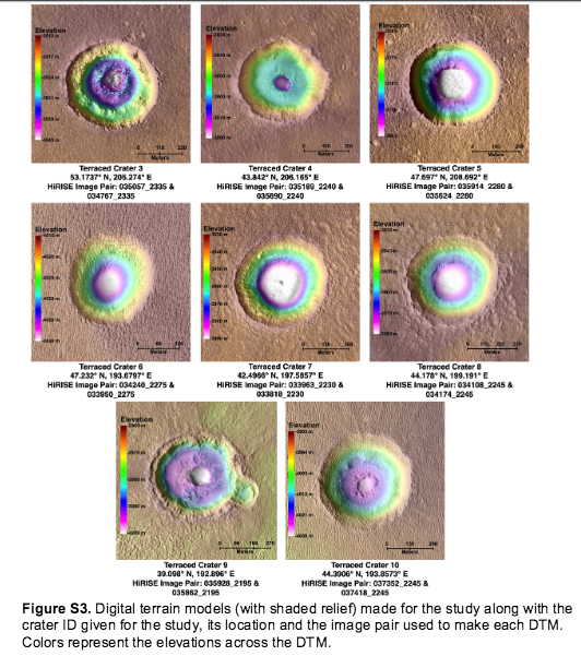
The distribution of subsurface water ice on Mars is a key constraint on past climate, while the volumetric concentration of buried ice (pore-filling versus excess) provides information about the process that led to its deposition. We investigate the subsurface of Arcadia Planitia by measuring the depth of terraces in simple impact craters and mapping a widespread subsurface reflection in radar sounding data. Assuming that the contrast in material strengths responsible for the terracing is the same dielectric interface that causes the radar reflection, we can combine these data to estimate the dielectric constant of the overlying material. We compare these results to a three-component dielectric mixing model to constrain composition. Our results indicate a widespread, decameters-thick layer that is excess water ice ~10^4 km^3 in volume. The accumulation and long-term preservation of this ice is a challenge for current Martian climate models.

Sunday, September 06, 2015

How Much Water was Needed to Carve the Late Noachian Valley Networks on Mars?

Late Noachian Fluvial Erosion on Mars: Cumulative Water Volumes Required to Carve the Valley Networks and Grain Size of Bed-Sediment

Authors:

Rosenberg et al

Abstract:

Our goal is to quantify the cumulative water volume that was required to carve the Late Noachian valley networks on Mars. We employ an improved methodology in which fluid/sediment flux ratios are based on empirical data, not assumed. We use a large quantity of data from terrestrial rivers to assess the variability of actual fluid/sediment flux sediment ratios. We find the flow depth by using an empirical relationship to estimate the fluid flux from the estimated channel width, and then using estimated grain sizes (theoretical sediment grain size predictions and comparison with observations by the Curiosity rover) to find the flow depth to which the resulting fluid flux corresponds. Assuming that the valley networks contained alluvial bed rivers, we find, from their current slopes and widths, that the onset of suspended transport occurs near the sand-gravel boundary. Thus, any bed sediment must have been fine gravel or coarser, whereas fine sediment would be carried downstream. Subsequent to the cessation of fluvial activity, aeolian processes have partially redistributed fine-grain particles in the valleys, often forming dunes. It seems likely that the dominant bed sediment size was near the threshold for suspension, and assuming that this was the case could make our final results underestimates, which is the same tendency that our other assumptions have. Making this assumption, we find a global equivalent layer (GEL) of 3 – 100 m of water to be the most probable cumulative volume that passed through the valley networks. This value is similar to the ∼34 m water GEL currently on the surface and in the near-surface in the form of ice. Note that the amount of water required to carve the valley networks could represent the same water recycled through a surface valley network hydrological system many times in separate or continuous precipitation/runoff/collection/evaporation/precipitation cycles.