Showing posts with label precolumbian. Show all posts

Tuesday, April 24, 2018

Paleogenetics Shed Light on Ancestry of the Inca

A multinational South American team from Peru, Brasil and Bolivia led by the Universidad de San Martin de Porres at Lima, Peru, published the first genetic study on the modern descendants of the imperial Inka lineages in the journal Molecular Genetics and Genomics. This work supported by funds from the Genographic Project (Geno 2.0), shows new insights about the Inkas origins and lineages.

The Inka people arrived to Cusco valley and in a few centuries they built the Tawantinsuyu, the largest empire in the Americas. The Tawantinsuyu was the cultural climax of 6,000 years of Central Andes civilizations overlapping modern countries of Peru, Bolivia, Ecuador, the South of Colombia and the North of Argentina and Chile. In contrast with the richness of archeological and cultural evidence, pre Columbian history vanishes in time as it intermingles with myths due to the lack of writing systems before the arrival of the European chroniclers. Very little is known about the Inka origins and some genetic information could help reconstruct part of their history. Unfortunately the mummies and bodily remains of the Inka emperors, worshiped as gods, were burnt and buried in unknown locations due to religious and political persecution by the Christian Conquistadors and Inquisitors, so no direct material remain to study their DNA. "Thus for now, only the genetic analysis of modern families of Inka descent could provide some clues about their ancestors" remarks geneticist Jose Sandoval, first author, working at Universidad de San Martin de Porres at Lima, Peru.

Monday, April 23, 2018

Evidence of the Importance of Animal Management for the Maya in Ceibal, Guatemala

Earliest isotopic evidence in the Maya region for animal management and long-distance trade at the site of Ceibal, Guatemala 
Authors: 
Sharpe et al 
Abstract: 
This study uses a multiisotope (carbon, nitrogen, oxygen, and strontium) approach to examine early animal management in the Maya region. An analysis of faunal specimens across almost 2,000 years (1000 BC to AD 950) at the site of Ceibal, Guatemala, reveals the earliest evidence for live-traded dogs and possible captive-reared taxa in the Americas. These animals may have been procured for ceremonial functions based on their location in the monumental site core, suggesting that animal management and trade began in the Maya area to promote special events, activities that were critical in the development of state society. Isotopic evidence for animal captivity at Ceibal reveals that animal management played a greater role in Maya communities than previously believed.

Monday, April 02, 2018

The PreColumbian Amazon had a Population of at Least One Million

Parts of the Amazon previously thought to have been almost uninhabited were really home to thriving populations of up to a million people, new research shows.

Archaeologists have uncovered evidence that there were hundreds of villages in the rainforest away from major rivers, and they were home to different communities speaking varied languages who had an impact on the environment around them.

Huge parts of the Amazon are still unexplored by archaeologists, particularly areas away from major rivers. People had assumed ancient communities had preferred to live near these waterways, but the new evidence shows this was not the case.

The discovery fills a major gap in the history of the Amazon, and provides further evidence that the rainforest -- once thought to be untouched by human farming or occupation -- has in fact been heavily influenced by those who lived in it.

Friday, March 09, 2018

Infant Head Shaping in PreColumbian Andes Examined

The idea of binding and reshaping a baby's head may make today's parents cringe, but for families in the Andes between 1100-1450, cranial modification was all the rage.

Like Chinese foot binding, the practice may have been a marker of group identity. Its period of popularity in what is now Peru, before the expansion of the Inca empire, was marked by political upheaval, ecological stress and the emergence of new cultural practices. In a study published in Current Anthropology, Matthew Velasco, assistant professor of anthropology at Cornell University, explores how head-shaping practices may have enabled political solidarity while furthering social inequality in the region.

Velasco analyzed hundreds of human skeletal remains from multiple tombs in the Colca Valley of highland Peru and discovered that before 1300 most people did not have modified heads. He found that the number of individuals with cranial modifications increased over time, from 39.2 percent to 73.7 percent during the later portion of the Late Intermediate Period.

Skeletal samples of two major ethnic groups showed that the Collaguas employed methods to make their heads assume a longer, narrower shape, while the Cavanas sought to make their heads wide and squat. Eventually, the elongated head shape of the Collaguas became the predominant style of modification in the upper Colca Valley. According to Velasco, this shift toward embodying a shared identity may have strengthened ties between groups engaged in protracted conflict with outsiders, including the Incas.

"The increased homogeny of head shapes suggests that modification practices contributed to the creation of a new collective identity and may have exacerbated emerging social differences," Velasco said. "Head shape would be an obvious signifier of affiliation and could have encouraged unity among elites and increased cooperation in politics."

Thursday, March 08, 2018

The Caribbean Taino Have Modern Descendants


Authors:

Schroeder et al

Abstract:

The Caribbean was one of the last parts of the Americas to be settled by humans, but how and when the islands were first occupied remains a matter of debate. Ancient DNA can help answering these questions, but the work has been hampered by poor DNA preservation. We report the genome sequence of a 1,000-year-old Lucayan Taino individual recovered from the site of Preacher’s Cave in the Bahamas. We sequenced her genome to 12.4-fold coverage and show that she is genetically most closely related to present-day Arawakan speakers from northern South America, suggesting that the ancestors of the Lucayans originated there. Further, we find no evidence for recent inbreeding or isolation in the ancient genome, suggesting that the Lucayans had a relatively large effective population size. Finally, we show that the native American components in some present-day Caribbean genomes are closely related to the ancient Taino, demonstrating an element of continuity between precontact populations and present-day Latino populations in the Caribbean.

John Hawks comments on the Science article about the above.

Wednesday, March 07, 2018

Reconstructing the Mayan Coastal Settlement at Vista Alegre


Authors:

Jaijel et al

Abstract:

Past coastal reconstruction is useful for understanding archaeological coastal settlements and predicting how coastal change might affect modern populations. The ancient Maritime Maya inhabitants of Vista Alegre in the northeastern Yucatan were active seafaring peoples. However, the past coastal landscape environmental history is unknown. Previous research concentrated on the fully terrestrial component of the site, and did not approach the issue from an earth sciences, sedimentological perspective. In this study, a sediment core campaign in the shallow offshore of Vista Alegre aimed to reconstruct the coastal and environmental changes that occurred over the past 3000 years, and specifically identify the changes in sea-level. Nine cores were analyzed using a multi-proxy approach including a range of sedimentological parameters such as granulometry, micropaleontology (foraminifera), radiocarbon dating, and loss on ignition. The sediment cores provided an archive of environmental changes related to sea-level change, anthropogenic influence, and shifting microenvironments which can be associated with cultural time periods. The environmental phases and shifts show some linkage to the archaeological chronology, suggesting an association between the environmental conditions and human activities. Sea-level changes and shifting shorelines have always been, and still are, a challenge for coastal settlements, and ancient sites can be a harbinger of what to anticipate in the future. In addition to this, current natural and anthropogenic pressures on coastlines are placing archaeological sites at increasing risk and thereby threatening this important scientific and cultural archive. Therefore, efforts to identify, characterize, and record natural and anthropogenic pressures prior to destruction are increasingly important.

Tuesday, March 06, 2018

LIDAR Finds Mayan Megapolis in Guatemalan Jungle

A vast Mayan megalopolis apparently lies hidden underneath all the trees, creepers and centuries of growth and soil in the Guatemalan forest -- and we might never have found it if not for the wonders of laser technology. The PACUNAM Foundation, which champions the use of scientific research to preserve cultural heritage, has scanned the jungles in the country using Light Detection and Ranging (LiDAR) technology and found an interconnected network of ancient cities. They discovered 60,000 previously unknown structures without having to cut down a single plant, and that discovery changes many things we thought we knew about the ancient civilization.

The sheer size of the megalopolis suggests that Mayan populations were bigger than we thought. Previous estimates put the Mayan people's population at around 5 million, but now it's possible that there were 10 to 15 million of them. The fact that the team discovered houses, pyramids, palaces and elevated highways even though Mayans didn't use wheels or relied of beasts on burden indicates that they had an organized workforce.

Monday, March 05, 2018

LIDAR Shows Purépecha Empire City Angamuco had as Many Buildings as Manhattan

When researchers surveyed the ruins of a Purépecha Empire city in Mexico the old-fashioned way a decade ago, it took them two seasons to explore two square kilometres. Good thing they decided to use LiDAR, because the city called Angamuco turned out bigger than they previously thought. LiDAR gave the researchers the power to see underneath the lava that covers Angamuco. Thanks to the laser technology, they now know that the city occupied 26 square kilometers of land instead of 13 square kilometers. Colorado State University archaeologist Chris Fisher is presenting that finding and all the latest info on his team's study at the ongoing American Association for the Advancement of Science conference in Austin.

"That is a huge area with a lot of people and a lot of architectural foundations that are represented," Fisher told The Guardian. According to their estimates, the city had around 1,500 structures per square kilometer of land. "If you do the maths," he added, "all of a sudden you are talking about 40,000 building foundations up there, which is [about] the same number of building foundations that are on the island of Manhattan." Further, LiDAR also led to the discovery that the city had an unusual layout, with big structures like pyramids and open plazas situated around the edges rather than in the center.

The Purépecha people existed at the same time as the Aztecs. While they are nowhere near as popular as their rivals, they were still a major civilization and had an imperial capital called Tzintzuntzan in western Mexico. Based on the team's LiDAR scans, though, Angamuco is even bigger Tzintzuntzan. It likely wasn't as densely populated, but Fisher said it's now the biggest city in western Mexico during that period that we know of.

Friday, February 10, 2017

Amazon Rain Forest NOT Pristine: Western Amazon has Over 450 Large Earthworks From 2,000 Years Ago


The Amazonian rainforest was transformed over two thousand years ago by ancient people who built hundreds of large, mysterious earthworks.

Findings by Brazilian and UK experts provide new evidence for how indigenous people lived in the Amazon before European people arrived in the region.

The ditched enclosures, in Acre state in the western Brazilian Amazon, were concealed for centuries by trees. Modern deforestation has allowed the discovery of more than 450 of these large geometrical geoglyphs.

The function of these mysterious sites is still little understood - they are unlikely to be villages, since archaeologists recover very few artefacts during excavation. The layout doesn't suggest they were built for defensive reasons. It is thought they were used only sporadically, perhaps as ritual gathering places.

The structures are ditched enclosures that occupy roughly 13,000 km2. Their discovery challenges assumptions that the rainforest ecosystem has been untouched by humans.


Friday, January 06, 2017

Chaco Canyon was Reliant on Food Imports

The ancient inhabitants of New Mexico's Chaco Canyon, the zenith of Pueblo culture in the Southwest a thousand years ago, likely had to import corn to feed the multitudes residing there, says a new University of Colorado Boulder study.

CU Boulder scientist Larry Benson said the new study shows that Chaco Canyon - believed by some archeologists to have been populated by several thousand people around A.D. 1100 and to have held political sway over an area twice the size of Ohio - had soils that were too salty for the effective growth of corn and beans.

"The important thing about this study is that it demonstrates you can't grow great quantities of corn in the Chaco valley floor," said Benson, an adjunct curator of anthropology at the University of Colorado Museum of Natural History. "And you couldn't grow sufficient corn in the side canyon tributaries of Chaco that would have been necessary to feed several thousand people.

"Either there were very few people living in Chaco Canyon, or corn was imported there."

A 6th Century Volcanic Eruption Disrupted Mayan Civilization


Authors:

Nooren et al

Abstract:

A remarkably long period of Northern Hemispheric cooling in the 6th century CE, which disrupted human societies across large parts of the globe, has been attributed to volcanic forcing of climate. A major tropical eruption in 540 CE is thought to have played a key role, but there is no consensus about the source volcano to date. Here, we present evidence for El Chichón in southern Mexico as the most likely candidate, based on a refined reconstruction of the volcano’s eruption history. A new chronological framework, derived from distal tephra deposits and the world’s largest Holocene beach ridge plain along the Gulf of Mexico, enabled us to positively link a major explosive event to a prominent volcanic sulfur spike in bipolar ice core records, dated at 540 CE. We speculate that voluminous tephra fall from the eruption had a severe environmental impact on Maya societies, leading to temporary cultural decline, site abandonment, and migration within the core area of Maya civilization.

Potential Impacts of Precolumbian Disruption of the Amazon Rain Forest

Ancient human disturbances may be skewing our understanding of Amazonian forests

Authors:

McMichael et al

Abstract:

Although the Amazon rainforest houses much of Earth’s biodiversity and plays a major role in the global carbon budget, estimates of tree biodiversity originate from fewer than 1,000 forest inventory plots, and estimates of carbon dynamics are derived from fewer than 200 recensus plots. It is well documented that the pre-European inhabitants of Amazonia actively transformed and modified the forest in many regions before their population collapse around 1491 AD; however, the impacts of these ancient disturbances remain entirely unaccounted for in the many highly influential studies using Amazonian forest plots. Here we examine whether Amazonian forest inventory plot locations are spatially biased toward areas with high probability of ancient human impacts. Our analyses reveal that forest inventory plots, and especially forest recensus plots, in all regions of Amazonia are located disproportionately near archaeological evidence and in areas likely to have ancient human impacts. Furthermore, regions of the Amazon that are relatively oversampled with inventory plots also contain the highest values of predicted ancient human impacts. Given the long lifespan of Amazonian trees, many forest inventory and recensus sites may still be recovering from past disturbances, potentially skewing our interpretations of forest dynamics and our understanding of how these forests are responding to global change. Empirical data on the human history of forest inventory sites are crucial for determining how past disturbances affect modern patterns of forest composition and carbon flux in Amazonian forests.

Friday, December 23, 2016

Divining Cahokia's Rise and Fall


A thousand years ago, huge pyramids and earthen mounds stood where East St. Louis sprawls today in Southern Illinois. This majestic urban architecture towered over the swampy Mississippi River floodplains, blotting out the region's tiny villages. Beginning in the late 900s, word about the city spread throughout the southeast. Thousands of people visited for feasts and rituals, lured by the promise of a new kind of civilization. Many decided to stay.

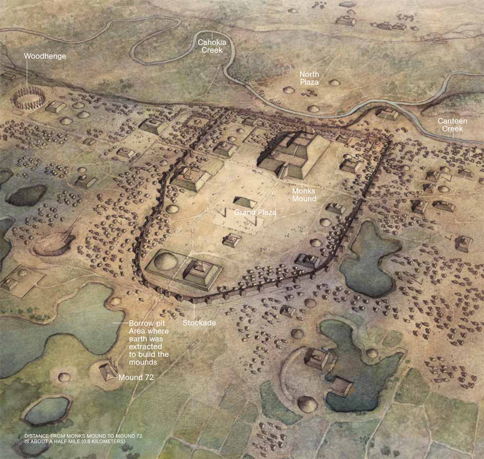
At the city's apex in 1100, the population exploded to as many as 30 thousand people. It was the largest pre-Columbian city in North America, bigger than London or Paris at the time. Its colorful wooden homes and monuments rose along the eastern side of the Mississippi, eventually spreading across the river to St. Louis. One particularly magnificent structure, known today as Monk’s Mound, marked the center of downtown. It towered 30 meters over an enormous central plaza and had three dramatic ascending levels, each covered in ceremonial buildings. Standing on the highest level, a person speaking loudly could be heard all the way across the Grand Plaza below. Flanking Monk’s Mound to the west was a circle of tall wooden poles, dubbed Woodhenge, that marked the solstices.

Despite its greatness, the city’s name has been lost to time. Its culture is known simply as Mississippian. When Europeans explored Illinois in the 17th century, the city had been abandoned for hundreds of years. At that time, the region was inhabited by the Cahokia, a tribe from the Illinois Confederation. Europeans decided to name the ancient city after them, despite the fact that the Cahokia themselves claimed no connection to it.

Centuries later, Cahokia's meteoric rise and fall remain a mystery. It was booming in 1050, and by 1400 its population had disappeared, leaving behind a landscape completely geoengineered by human hands. Looking for clues about its history, archaeologists dig through the thick, wet, stubborn clay that Cahokians once used to construct their mounds. Buried beneath just a few feet of earth are millennia-old building foundations, trash pits, the cryptic remains of public rituals, and in some places, even, graves.

Thursday, August 18, 2016

Lessons From Mayan Astronomy


Author:

Loeb

Abstract:

The Mayan culture collected exquisite astronomical data for over a millennium. However, it failed to come up with the breakthrough ideas of modern astronomy because the data was analyzed within a mythological culture of astrology that rested upon false but mathematically sophisticated theories about the Universe. Have we learned the necessary lessons to prevent our current scientific culture from resembling Mayan Astronomy? Clearly, data collection by itself is not a guarantee for good science as commonly assumed by funding agencies. A vibrant scientific culture should cultivate multiple approaches to analyzing existing data and to collecting new data.

Friday, July 29, 2016

Water Tunnels Beneath Mayan Temple had Religious Function

Not long before his demise in 683 AD, the ancient ruler Pakal ordered what was one of the Mayan's most ambitious construction projects. The magnificent, nine-level Temple of the Inscriptions went on to house his body for centuries, but it was the intricate stone carvings found in the tomb that have inspired debate about the king's plans for the afterlife. Archaeologists have now unearthed a network of water tunnels beneath Pakal's tomb, which they say not only offers an indication of his intentions to float way to the underworld, but reframes theories about how the grand pyramid itself was built.

The stone slab that topped Pakal's 20-ton sarcophagus was covered with carvings appearing to depict the ruler's resurrection in the afterlife. It has since become an intensely studied example of classic Mayan artwork. In it, Pakal himself appears tilted backwards in front of a tree, surrounded by glyphs and cosmological signs.

This portrayal caught the eye of certain ancient alien theorists, who interpreted the slab to show Pakal at the controls of a spaceship making his way through the Milky Way (a full-size wooden replica even popped up at the International UFO Museum in Roswell, New Mexico).

But the discovery of the underwater tunnels beneath the Temple of the Inscriptions appears to suggest that Pakal's spirit was sent down the gurgler (taking the far-fetched spaceship theory along with it). The canals were found by researchers from Mexico's National Institute of Anthropology, who began digging at the site in 2012 after picking up anomalies under the ground with a geo-radar they feared could cause the pyramid to collapse.

Thursday, July 21, 2016

Climate had a big Impact on the Maya


Authors:

Akers et al

Abstract:

The stalagmite MC01 was recovered from Macal Chasm cave on the Vaca Plateau of Belize in 1995, and an initial paleoclimate interpretation was published in 2007. Additional uranium-thorium ages have extended the paleoenvironmental record back from 3250 to 5250 cal yr BP, and the stable isotope (δ18O and δ13C) record is dramatically improved by 660 new values. A series of major dry events (MDEs) evident in stable isotopes, ultraviolet-stimulated luminescence, and petrography began ~ 3100 cal yr BP, and the initiation of these events coincides with an increase in El Niño dominance and southern shift in the Intertropical Convergence Zone. Three MDEs, centered at 1750 cal yr BP (200 CE), 1100 cal yr BP (850 CE), and 850 cal yr BP (1100 CE) and found in other regional climate records, coincide with Maya sociopolitical changes. Residuals from regression of δ13C versus δ18O are interpreted as a proxy for maize cultivation and land clearing, with residual values gradually increasing at the start of Preclassic Period settlement (3950 cal yr BP/2000 BCE), peaking after 2250 cal yr BP (300 BCE) during major Maya development in the Late Preclassic and Classic Periods, and dropping to pre-Preclassic values after regional land abandonment (~ 850 cal yr BP/1100 CE). Regional Maya population growth and cultural expansion may have been aided by abnormally low precipitation variability, as stable isotope variability suggests the Late Preclassic through the Late Classic was the most stable precipitation regime of the past 4000 years. This additional research on MC01 complements other regional paleoenvironmental records that suggest that MDEs coincided with disruptions in Maya society from the Preclassic through the Postclassic Periods. Although it is clear that not all significant sociopolitical changes can be attributed to the MDEs, these events likely played an antagonistic role in social stability.

Friday, July 08, 2016

Precolumbian Brazilian Pithouses Were Occupied for More Than two Centuries

Ancient inhabitants of the southern Brazilian highlands were no strangers to the types of home improvements we enjoy today, academics from the University of Exeter have found.

New research has shown for the first time how oversized pit houses in the southern Brazilian highlands were used for centuries thanks to careful repairs by generations of owners.

This is the first evidence that these oversized pit houses in region were continuously occupied.

Academics have demonstrated one house was occupied for more than two centuries.

Friday, July 01, 2016

Geospatial modeling approach to monument construction for Precolumbian Michigan

Geospatial modeling approach to monument construction using Michigan from A.D. 1000–1600 as a case study

Authors:

Howey et al

Abstract:

Building monuments was one way that past societies reconfigured their landscapes in response to shifting social and ecological factors. Understanding the connections between those factors and monument construction is critical, especially when multiple types of monuments were constructed across the same landscape. Geospatial technologies enable past cultural activities and environmental variables to be examined together at large scales. Many geospatial modeling approaches, however, are not designed for presence-only (occurrence) data, which can be limiting given that many archaeological site records are presence only. We use maximum entropy modeling (MaxEnt), which works with presence-only data, to predict the distribution of monuments across large landscapes, and we analyze MaxEnt output to quantify the contributions of spatioenvironmental variables to predicted distributions. We apply our approach to co-occurring Late Precontact (ca. A.D. 1000–1600) monuments in Michigan: (i) mounds and (ii) earthwork enclosures. Many of these features have been destroyed by modern development, and therefore, we conducted archival research to develop our monument occurrence database. We modeled each monument type separately using the same input variables. Analyzing variable contribution to MaxEnt output, we show that mound and enclosure landscape suitability was driven by contrasting variables. Proximity to inland lakes was key to mound placement, and proximity to rivers was key to sacred enclosures. This juxtaposition suggests that mounds met local needs for resource procurement success, whereas enclosures filled broader regional needs for intergroup exchange and shared ritual. Our study shows how MaxEnt can be used to develop sophisticated models of past cultural processes, including monument building, with imperfect, limited, presence-only data.

Friday, June 24, 2016

Studying the Expansion of the Squash Bee With PreColumbian Agriculture

Using genetic markers, researchers have for the first time shown how cultivating a specific crop led to the expansion of a pollinator species. In this case, the researchers found that the spread of a bee species in pre-Columbian Central and North America was tied to the spread of squash agriculture.

"We wanted to understand what happens when the range of a bee expands," says Margarita López-Uribe, a postdoctoral researcher at North Carolina State University and lead author of a paper describing the work. "What does that mean for its genetic variability? And if the genetic variability declines, does that harm the viability of the species?"

To explore these questions, researchers looked at the squash bee (Peponapis pruinosa), which is indigenous to what is now central Mexico and the southwestern United States. Squash bees are specialists, collecting pollen solely from the flowers of plants in the genus Cucurbita, such as squash, zucchini and pumpkins.

Before contact with Europeans, native American peoples had begun cultivating Cucurbita crops. Over time, these agricultural practices spread to the north and east.

"We wanted to know whether P. pruinosa spread along with those crops," López-Uribe says.

To find out, researchers looked at DNA from squash bee individuals, collected from throughout the species' range. P. pruinosa can now be found from southern Mexico to California and Idaho in the west, and from Georgia in the southeast to Quebec in the north.

By assessing genetic markers in each bee's DNA, the researchers could identify genetic signatures associated with when and where the species expanded.


Thursday, June 09, 2016

Evidence of PreColumbian Eurasian-Inuit Trade

Evidence of Eurasian metal alloys on the Alaskan coast in prehistory

Authors:

Cooper et al

Abstract:

Six metal and composite metal artifacts were excavated from a late prehistoric archaeological context at Cape Espenberg on the northern coast of the Seward Peninsula in Alaska. X-ray fluorescence identified two of these artifacts as smelted industrial alloys with large proportions of tin and lead. The presence of smelted alloys in a prehistoric Inuit context in northwest Alaska is demonstrated here for the first time and indicates the movement of Eurasian metal across the Bering Strait into North America before sustained contact with Europeans.