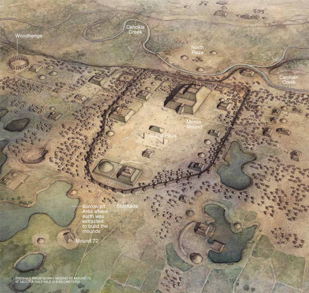
A thousand years ago, huge pyramids and earthen mounds stood where East St. Louis sprawls today in Southern Illinois. This majestic urban architecture towered over the swampy Mississippi River floodplains, blotting out the region's tiny villages. Beginning in the late 900s, word about the city spread throughout the southeast. Thousands of people visited for feasts and rituals, lured by the promise of a new kind of civilization. Many decided to stay.
At the city's apex in 1100, the population exploded to as many as 30 thousand people. It was the largest pre-Columbian city in North America, bigger than London or Paris at the time. Its colorful wooden homes and monuments rose along the eastern side of the Mississippi, eventually spreading across the river to St. Louis. One particularly magnificent structure, known today as Monk’s Mound, marked the center of downtown. It towered 30 meters over an enormous central plaza and had three dramatic ascending levels, each covered in ceremonial buildings. Standing on the highest level, a person speaking loudly could be heard all the way across the Grand Plaza below. Flanking Monk’s Mound to the west was a circle of tall wooden poles, dubbed Woodhenge, that marked the solstices.
Despite its greatness, the city’s name has been lost to time. Its culture is known simply as Mississippian. When Europeans explored Illinois in the 17th century, the city had been abandoned for hundreds of years. At that time, the region was inhabited by the Cahokia, a tribe from the Illinois Confederation. Europeans decided to name the ancient city after them, despite the fact that the Cahokia themselves claimed no connection to it.
Centuries later, Cahokia's meteoric rise and fall remain a mystery. It was booming in 1050, and by 1400 its population had disappeared, leaving behind a landscape completely geoengineered by human hands. Looking for clues about its history, archaeologists dig through the thick, wet, stubborn clay that Cahokians once used to construct their mounds. Buried beneath just a few feet of earth are millennia-old building foundations, trash pits, the cryptic remains of public rituals, and in some places, even, graves.

Dr. Thomas E. Emerson and Dr. Kristin M. Hedman from the Illinois State Archaeological Survey-Prairie Research Institute at the University of Illinois present a new case for Cahokia's demise. The new theory was published in Southern Illinois University Press' volume, Beyond Collapse: Archaeological Perspectives on Resilience, Revitalization, and Transformation in Complex Societies. Emerson and Hedman contributed a chapter to the volume entitled, The Dangers of Diversity: The Consolidation and Dissolution of Cahokia, Native North America's First Urban Polity, that explores internal divisions that led to the collapse of Cahokia.
The archaeologists claim internal conflict by social, political, ethnic, and religious factions are a more reasonable description of events that led to Cahokia's collapse than environmental causes, as is the popular theory. They present new bioarchaeological evidence that demonstrates that as many as one-third of the Cahokian residents were immigrants and that these immigrants likely represented groups that were culturally, ethnically, and perhaps linguistically distinct from local populations. Emerson clarifies further,
Cahokia’s emergence and decline coincided with shifts of flood frequency on the Mississippi River
Authors:
Munoz et al
Abstract:
Here we establish the timing of major flood events of the central Mississippi River over the last 1,800 y, using floodwater sediments deposited in two floodplain lakes. Shifts in the frequency of high-magnitude floods are mediated by moisture availability over midcontinental North America and correspond to the emergence and decline of Cahokia—a major late prehistoric settlement in the Mississippi River floodplain. The absence of large floods from A.D. 600 to A.D. 1200 facilitated agricultural intensification, population growth, and settlement expansion across the floodplain that are associated with the emergence of Cahokia as a regional center around A.D. 1050. The return of large floods after A.D. 1200, driven by waning midcontinental aridity, marks the onset of sociopolitical reorganization and depopulation that culminate in the abandonment of Cahokia and the surrounding region by A.D. 1350. Shifts in the frequency and magnitude of flooding may be an underappreciated but critical factor in the formation and dissolution of social complexity in early agricultural societies.
Using LiDAR data to locate a Middle Woodland enclosure and associated mounds, Louisa County, Iowa
Authors:
Riley et al
Abstract:
LiDAR data is used to locate an enclosure reported at the McKinney site (13LA1) as well as destroyed mounds associated with the Toolesboro mound group National Historic Landmark (13LA29). Using various geo-visualization and interpolation techniques, one of us (Riley) located the earthwork enclosure, eight mounds, and possibly a ninth or an excavation spoil pile. An anomaly north of 13LA1 and within the detected enclosure area were also identified. There is no modern survey relating to these two anomalies. Our results support historic accounts regarding the location and shape of the McKinney enclosure and its relationship to the Toolesboro mound group. All features found by LiDAR will be ground truthed in the future.